The Odessa Aquifers


THE ODESSA AQUIFERS
The Odessa aquifers are part of the regional Columbia Basin basalt aquifer system.
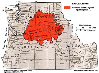
Map: Columbia Plateau regional aquifer system -- a large approximately circular basalt system underlain primarily by Miocene basaltic rocks. (Source: Ground Water Atlas of the United States: Idaho, Oregon, Washington, USGS, figure 69.)
Locally the Odessa Aquifers discharge to Crab Creek (which is suffering from low flows, see below); regionally the Columbia basalt aquifers discharge to the Columbia River, near the Quad Cities.
Diagram: The Columbia Plateau regional aquifer system consists primarily of three basalt formations separated by confining units. The Grand Ronde Basalt and the overlying Wanapum and Saddle Mountains Basalt, which are called the Columbia River Basalt Group, compose most of the aquifer system. (Source: USGS, Ground Water Atlas of the United States: Idaho, Oregon, Washington)
Basalt aquifers are like a layer cake, with water-bearing fracture zones interspersed between dense layers of basalt that are mostly impermeable to water flow.
Diagram: Cross-section for Crab Creek and its tributaries. Note the layering. The structure of the sediment-filed coulees shown here influences the presence and movement of groundwater in the aquifer. (Source: WRIA 43 Watershed Assessment)
While the amount of water held in the basalts can be large, the recharge in the semi-arid Columbia basin is quite small, averaging 10 inches per year or less in the region. Not surprisingly, in areas where intensive pumping is occurring, water levels are declining. In fact, basalt aquifer levels are declining not only in Odessa, but in several areas around the Columbia Plateau, including Moscow-Pullman, Umatilla, and the Yakima basin.
In the Odessa Aquifers, intensive human use of the basalt aquifers is a second cause of groundwater depletion. Irrigation and municipal wells penetrate the basalt layers at depths of up to 1,000 to 2,000 feet below ground surface. The state of Washington has been aware that the Odessa Aquifers were declining since irrigation pumping began in the early 1960s when two studies were published that identified the problem of overpumping.
Photo: Irrigation system, Odessa subarea.
In 1973, the Department of Ecology adopted a regulation requiring that Odessa Aquifers could not decline more than an average of 30 feet every 3 years before regulatory action would be taken. (Washington Administrative Code Chapter 173-130A, Odessa Ground Water Subarea Management Policy (adopted 1973, amended 1982)). See also Chapter 173-128A WAC
According to measurements, this has been (more or less) the actual rate of decline for the Odessa aquifers.
Sources: The three studies described at left document groundwater decline in the Odessa Subarea.
Even though the state adopted a regulation to allow it, the “mining” of the Odessa Aquifers appears to be illegal under Washington state water law. Nonetheless, the state has never stepped in to prevent the declines.


1968
USGS: Ground-water withdrawal in the Odessa area, Adams, Grant, and Lincoln Counties, Washington
Water Supply Bulletin 31 (1968) describes an investigation into the effects of large-scale ground water withdrawal in the Odessa area, including predictions of the future effects of pumping. This bulletin includes well log records and water level measurements for selected wells in Adams, Grant, and Lincoln counties, WA.

USGS: Ground-water survey, Odessa-Lind area, Washington
Water Supply Bulletin 36 (1968) describes the occurrence of groundwater and the response of the groundwater level to irrigation pumping in the Odessa-Lind area. The study area described in this bulletin includes portions Lincoln and Adams counties, WA.
* Book

1984
USGS and Wash Dept of Ecology:
Ground-water levels and pumpage in east-central Washington, including the Odessa-Lind Area, 1967-1081
“Since 1967 the area affected by water-level declines has expanded and shifted and the rate of decline has increased. The maximum decline of water levels from 1968 to 1981 has occurred in southern Adams County -- about 130 feet in wells that tap the Wanapum Basalt and about 160 feet in wells that tap the Wanapum and Grande Ronde Basalts.” Full text of report, click here.