Odessa Aquifers:
Crisis in Sustainability
~
Introduction

Odessa Aquifers:
Crisis in Sustainability
~
Introduction
The “Odessa Subarea” is a 2,053 square-mile agricultural area in the mid- and east-Columbia Plateau in Washington state, encompassing parts of Adams, Franklin, Grant and Lincoln Counties. The area is semi-arid, averaging about 10 inches per year of precipitation, with a few small surface water bodies, including Upper Crab Creek.

Map showing the Odessa Subarea. To enlarge, click here. (source: Initial Alternative Development & Evaluation, Odessa Subarea Special Study, U.S. Bureau of Reclamation, Sept. 2006)
About half the area is farmed in dry-land wheat. Roughly 170,000 acres of the Odessa Subarea are irrigated to grow potatoes, peas and higher yield wheat. The source of water for irrigation is groundwater – the Odessa Subarea aquifer system.
The Odessa Aquifers are a series of fractured basalt rock layers that extend a few thousand feet deep. This is the same aquifer system that underlies the entire Columbia Plateau, but this area has been administratively delineated as the “Odessa Subarea.”
The Odessa Aquifers have been declining at a significant rate – so significant that some farmers in the area can no longer access water from their wells. Three distinct factors, one natural and two human-caused, contribute to the problem of declining groundwater levels.
First, the basalt hydrogeology of the area is a significant limiting factor on water development. Second, farmers are pumping water at a rate that far outstrips natural recharge. Third, badly constructed wells allow water to drain from upper to lower aquifers, causing water levels to fall to levels that are too difficult and/or expensive to access. Each of these factors is examined below.
(next: The Odessa Aquifers)


Map source: “Ecology Investment Atlas, Columbia Basin Projects, July 1, 2005 - June 30, 2007, $18,626,693” WA Dept of Ecology.
Click here to enlarge


Dryland wheat farming on the Columbia River plateau.
(photo: Rachael Paschal Osborn)
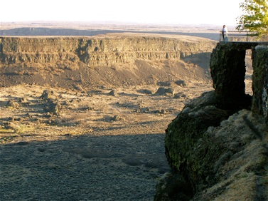
Fractured basalts, Dry Falls.
(photo: John Osborn)
Satellite image of agricultural landscape near Ritzville, Washington (ISS013-E-34038), above, and the Columbia River Plateau (STS028-73-42), below. Image courtesy of the Image Science & Analysis Laboratory, NASA Johnson Space Center.

Columbia Institute for Water Policy