Odessa solutions:
Water Importation

Several water importation schemes are proposed for the Odessa Subarea, almost all of them focused on diverting additional water from the Columbia River.
In addition to depleting instream flows that are needed for Columbia River fisheries, diverting water from Lake Roosevelt for the Odessa Subarea could lead to water quality and recreational impacts. See map and photos at left, and the “Columbia River Dam Building” page for more information.
This section examines the U.S. Bureau of Reclamation’s new water right application, along with studies recently issued by the State and the Bureau, including the USBR Odessa Subarea Special Study, Washington’s Off Channel Dam Study, the Potholes Alternative Feed Route Study, and the “aquifer storage and recovery” concept.
THE USBR WATER RIGHT APPLICATION
In December 2004, as part of its Columbia River agenda, the State of Washington signed a Memorandum of Understanding (MOU) with the U.S. Bureau of Reclamation and the CBP irrigation districts. Among other activities, the MOU provides that the parties will cooperate to explore opportunities for delivery of water to the Odessa Subarea.
Pursuant to the MOU, the Bureau of Reclamation has applied for a state water permit in the amount of 200 cfs and 30,000 acre-feet per year to serve 10,000 acres in the Odessa Subarea. In order to transport this water to Odessa, the Bureau must free up space in the CBP’s East Low Canal. To do this, the Bureau is studying alternative feed routes to Potholes Reservoir (discussed below).
Although the water right application was filed in 2005, USBR claims a 1938 priority date, which predates Washington’s minimum instream flow requirements for the Columbia River. Any new diversion is supposed to be accompanied by a release of water to protect instream flows in the Columbia River. The Bureau has not applied for the instream right.
USBR discretion is not, however, unfettered. As noted in the Odessa Special Study (discussed below), “the Bureau will need to comply with NEPA, consult under the ESA, and address other issues before it can divert additional water from the Columbia River . . . It will be a challenge to provide water during the summer months, and during spring and summer months in drier years, when Columbia River diversions may be restricted because of fish flow objectives for species listed under the ESA.” (Odessa Subarea Special Study, Sept. 2006, p. 27).
USBR would also have to find and fund a mechanism to deliver this water to eligible Odessa Subarea lands.
The Department of Ecology has prepared a draft environmental impact analysis of this proposal (termed “Lake Roosevelt Drawdown” in its Programmatic EIS for the Columbia River Water Management Program). The analysis, which is perfunctory, concludes that withdrawing more water from Lake Roosevelt is within normal operating conditions and therefore has few impacts. There is no discussion of cumulative effects or climate change.
In addition, an agreement between the Department of Ecology and the Confederated Colville Tribes would require substantial mitigation before Lake Roosevelt drawdown could occur. Adverse impacts include, among other problems, exposure of Lake Roosevelt sediments, which are laced with slag and toxic chemicals due to pollution from the Teck Cominco smelting factory, upstream in Canada.
USBR’s ODESSA SUBAREA SPECIAL STUDY
The Bureau of Reclamation is now studying whether to complete the Odessa portion of the Columbia Basin Project. This five-year study (due in 2010), supported by state and federal tax dollars, is explicitly premised on the goal of securing surface water to replace groundwater in the Odessa Subarea. The study contains no discussion of other options (e.g., direct payments or retirement of irrigation lands).
Photo: Front cover of “Initial Alternative Development and Evaluation, Odessa Subarea Special Study, Columbia Basin Project”, September 2006.
Link to USBR Odessa Subarea Special Study
USBR’s Odessa study has narrowed the delivery options to four alternatives. Three alternatives require substantial extension or enlargement of CBP irrigation canals. The fourth alternative would extend delivery pipelines from the existing canal system eastward to serve an estimated 48,000 acres. No cost estimates have been offered for these alternatives, but the first three would likely require hundreds of millions of dollars in infrastructure investments.
Map: “Alternative A” would build substantial new infrastructure to deliver surface water to lands presently irrigated with groundwater in the Odessa Subarea. Source: USBR, Odessa Subarea Special Study, Figure 2. Click here to enlarge.
In addition to physical construction, all options require new and additional water supply, ranging up to 520,000 acre feet of water. The Bureau therefore analyzed eleven water supply options, all but one of which entail inundation of terrestrial areas. The only option without impacts, “canal system efficiency improvements,” is deferred to a “later date” for discussion among the three irrigation districts that operate within the CBP.
The Bureau of Reclamation has identified Dry Coulee, Rocky Coulee, Lind Coulee and Lower Crab Creek as potential sites for inundation (Options 5, 6, 7 and 8 in the map at left). None of these areas produces sufficient water to fill a reservoir, so the Bureau would import Columbia River water to operate these sites as “off-stream reservoirs.” As noted above, diversion from the Columbia River would require substantial mitigation to address endangered species, water quality, and tribal resource issues. The Bureau of Reclamation has not yet projected costs, but the financing for these proposals would be substantial.
Table 5 in the USBR study provides data on impacts associated with shrub-steppe and wetland acreage, houses and roads.
WASHINGTON’S NEW DAM BUILDING PROGRAM
Washington is promoting the construction of one or more new dams & reservoirs to be located near the Columbia River and which would divert from and store Columbia River water supply. Depending on location, the state of Washington projects that these dams could serve as a source of supply for Odessa Subarea farms.
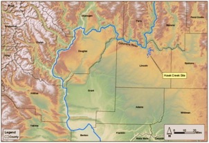
Photo: Hawk Creek Canyon, potentially targeted for a dam to supply water to the Odessa subarea.
According to the Department of Ecology, dam sites have been narrowed to include Hawk Creek, Foster Creek, Sand Hollow Creek and Lower Crab Creek. The environmental impacts associated with these proposals would be tremendous. Pre-appraisal cost estimates for the reservoirs range from $1 billion to $3 billion for each site.
Link to the Mainstem Off-Channel Report
Map: Proposed dam and reservoir site on Hawk Creek. (Source: “Off-channel storage assessment pre-appraisal report.” Washington Dep’t of Ecology and USBR, December 2005, p. 42).
POTHOLES FEED ROUTE
The East Low Canal of the CBP is filled to capacity. In order to free up space for water to be distributed to the Odessa Subarea, the Bureau of Reclamation is studying alternative routes for delivering water to the Potholes Reservoir, which serves south Columbia Basin Project farms.
Photo: Potholes wetlands (Source: USBR)
Three routes are proposed, but the favored option would utilize the natural channel of Upper Crab Creek. Changing water supply routes could alter wetlands and recreational sites in the area.
The Department of Ecology’s Programmatic Environmental Impact Statement for the Columbia River Water Management Program (in draft as of November 2006) examines (perfunctorily) the “Supplemental Feed Route” option. However, the PEIS does not acknowledge its connection to the Bureau’s proposals to bring water to the Odessa Subarea.
Link to USBR Pothole Feed Route website
Map: Potholes feed route alternatives. (Source: Programmatic Environmental Impact Statement for the Columbia River Water Management Program, Figure 2-4.) Click here to enlarge map.
AQUIFER STORAGE & RECOVERY
ASR (aquifer storage and recovery) and pipeline proposals are infeasible from both physical and economic standpoints. ASR involves injecting water into aquifers via wells or surface infiltration and then withdrawing it at a later date. It requires that the target aquifer be able to store water within a discreet area, an unlikely prospect in the leaky Odessa Aquifers. The Ecology-USBR Memorandum of Understanding (discussed above) provides for “appraisal level” assessment of an aquifer recharge project for the Odessa Subarea. However, no studies are currently underway, nor is a source of water and the means to transport it available.
Illustration: Idealized cross section of flow in Yakima Basalt Subgroup. Source:Guides to Some Volcanic Terrances in Washington, Idaho, Oregon, and Northern California, USGS Geological Survey Circular 838)
Next: Water Conservation


“It will be a challenge to provide water during the summer months, and during spring and summer months in drier years, when Columbia River diversions may be restricted because of fish flow objectives for species listed under the ESA.”
USBR, Odessa Subarea Special Study, Sept. 2006, p. 27


Map & Photos: Diversion from Lake Roosevelt Reservoir could create significant water quality impacts. Lake Roosevelt is contaminated with smelter wastes historically dumped into the River in by Teck Cominco. Any option to divert water from the lake must address exposure of this contamination. For more on Lake Roosevelt’s slag-covered “black sand beaches”, see EPA’s website.