Unstable Geology

Black Rock lies in a seismically active area, on top of a fault zone, and beneath landslide-prone slopes.
Black Rock reservoir is proposed to be built in the Yakima Fold Belt, a geologic region that is prone to large (magnitude 6 to 7-plus) earthquakes. A thrust fault underlies the proposed dam site (see diagram). Core samples of the geologic strata beneath the proposed dam site have been described as looking like “kibble” (dog food), much of which would have to be excavated to seat the dam.
Despite these problems, Bureau of Reclamation engineers conclude that the dam can be built to safety standards. Nonetheless, Black Rock does not appear to be a wise location to invest $4 billion in dam construction funds.
“Initial geologic mapping indicates that a significant thrust fault is present in the right abutment of the proposed dam site. . . . This fault is considered a potential earthquake source. If large earthquakes occur on this fault, they could potentially be accompanied by up to several meters of surface faulting. The age and characteristics of this fault need further studies for issues related to seismic source characterization at the site.”
From Appraisal Assessment of the Black Rock Alternative Facilities and Field Cost Estimates, U.S. Bureau of Reclamation (Dec. 2004)
Reservoir Landslides.
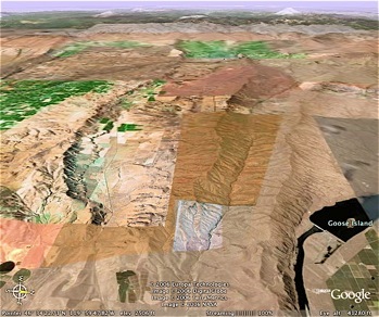
The Black Rock Reservoir could be subject to landslides on the steep slopes of Rattlesnake Ridge that would serve as the south bank of the proposed reservoir. Landslides can displace reservoir water, causing it to overtop and otherwise de-stabilize dams. The Bureau of Reclamation’s report on Black Rock geology identifies two large landslide areas adjacent to and upstream of the proposed dam site. Annual fluctuations in water levels could cause landslides into the Black Rock reservoir.
This is not a theoretical problem. Lake Roosevelt was subject to a series of large landslides between 1943 and 1954, as the reservoir was annually filled and emptied. These landslides caused large, fast-moving waves to travel several miles across the reservoir, wiping out structures in their path. Grand Coulee dam was not threatened, presumably because Lake Roosevelt is more than 100 miles long and the landslides occurred well upstream of the dam. In contrast, Black Rock reservoir would only be a few miles long.
For information about Lake Roosevelt’s historic landslides, see Washington State Hazard Mitigation Plan, Hazard Profile – Tsunami, Tab 7.1.7, pp. 5-6 (July 2004), Washington Emergency Management Division.
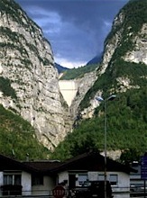
Large landslides into reservoirs can cause catastrophic problems, as occurred in Vajont, Italy in 1963. There, the filling of a newly constructed dam caused a massive landslide and 100 foot tsunami that overtopped the dam, wiping out several small villages and killing more than 2,000 people. For more on the Vajont reservoir landslide disaster, click here.
“The initial assessment indicates that the Black Rock damsite lies in an area of relatively high earthquake potential. . . . [I]t is assumed at this stage of study that the fault may be capable of large-magnitude earthquake and that associated fault offsets within the dam footprint could range from a few centimeters to several meters.”
~ From Black Rock Alternative Facilities Assessment, Section 5.3.4 (Seismotectonics).
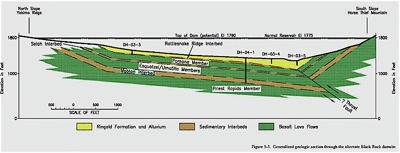
Above: Cross section showing dam site and geology with thrust fault. U.S. Bureau of Reclamation considers this fault “a potential earthquake source”. Click here to enlarge.
Source: USGS.

Columbia Institute for Water Policy
Black Rock Follies © 2007
“On October 9, 1963 at approximately 10:35pm, the combination of the third drawing-down of the reservoir and heavy rains triggered an enormous landslide of about 260 million cubic metres of forest, earth, and rock, which fell into the reservoir at up to 110 km per hour (68 mph). The resulting displacement of water caused 50 million cubic metres of water to overtop the dam in a 250-metre high wave. Despite this, the dam's structure was largely undamaged — the top metre or so of masonry was washed away, but the basic structure remained intact. However, the megatsunami caused by the landslide totally destroyed the village of Longarone and the small villages of Pirago, Rivalta, Villanova and Faè, killing 1,450 people. Many small villages in the territory of Erto e Casso and the village of Codissago, near Castellavazzo, were largely wrecked. Almost 2,000 people (some sources report 1,909) perished in total. Damage was also caused by the air displacement caused from the immense "splash" in surrounding villages.” Source: “Vajont Dam” Wikipedia
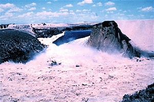
Teton Dam collapse. June 5, 1976. “Teton Dam near Rexburg, Idaho suddenly failed on first filling of the reservoir in 1976. To determine what impacts occurred in this upstream canyon reach (from the filling of Teton Reservoir and subsequent failure of Teton Dam), a geomorphology and river hydraulics study was completed by Reclamation during 1997-2000, more than 20 years after the dam failure. When Teton Dam failed, the reservoir was 270 feet deep (at the dam) and drained in less than six hours. The filling and the subsequent rapid draining of the reservoir triggered more than 200 landslides in the river canyon that was inundated by the former reservoir.” “The failure of Teton Dam resulted in the loss of 11 lives and millions of dollars in property damage.” Source: U.S Bureau of Reclamation, “The Failure of Teton Dam.”
The Vajont Dam as seen from Longarone
Black Rock Reservoir site 
Thrust fault
beneath
proposed Black Rock Dam.